Nautical Mile: 1,852 m, While a Minute of Latitude Varies
The Yardstick Almanac Published No substantive revisions
Short answer
The nautical mile is defined as 1,852 m [exact by definition]. On the WGS 84 ellipsoid, a minute of latitude runs about 1,843 m at the equator to 1,862 m at the poles.
Station index 4 sections
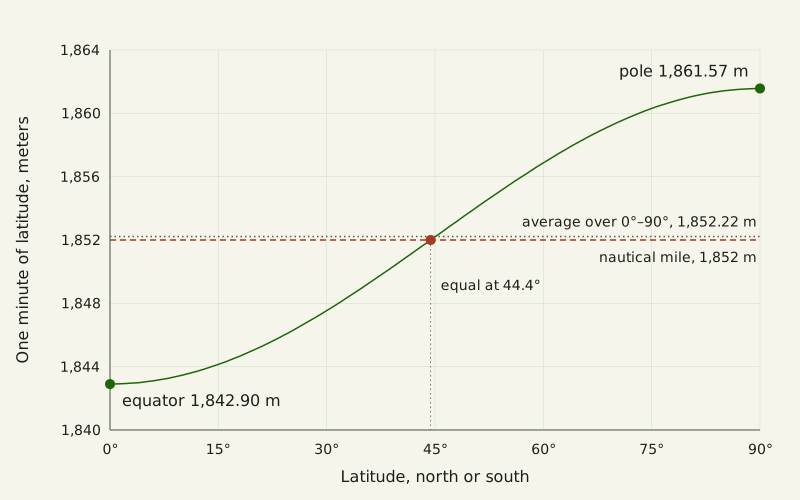
Figure: The Yardstick Almanac, CC BY 4.0
Credit line to copy
"One minute of latitude on WGS 84 against the 1852 m nautical mile" by The Yardstick Almanac, https://theyardstickalmanac.com/units/nautical-mile/, licensed under CC BY 4.0 (https://creativecommons.org/licenses/by/4.0/).
Data: Computed 2026-11-01 from the WGS 84 constants in PROJ 9.8.1 src/ellps.cpp (MIT license) and the 1852 m definition in the BIPM SI Brochure, 9th ed. V4.01 (CC BY 4.0; adapted: the defined value used in new calculations); CC BY 4.0
A minute of latitude runs about 1,843 meters at the equator, 1,862 at the poles; the nautical mile is 1,852. The 1,852 m figure dates from 1929, when the 1st Extraordinary International Hydrographic Conference fixed it, as the International Bureau of Weights and Measures (BIPM) records in its SI Brochure. The latitude figures are our own, computed on the WGS 84 ellipsoid.
The 2006 edition of that brochure says the unit was originally chosen because one nautical mile subtends about one minute of angle at Earth's center. The round 1,852 m keeps none of the variation in the real minute. That gap is the rounding remainder this page follows, our name for what a measurement convention leaves unmatched.
In numbers: a nautical mile is defined as 1,852 m [exact by definition], which is about 1.150779 statute miles (rounded) [exact by definition] and 6,076.11549 international feet (rounded) [exact by definition]. On the WGS 84 ellipsoid, one minute of latitude is 1,842.90 m at the equator and 1,861.57 m at the poles (rounded) [exact by definition], a spread of about 18.7 m. Averaged evenly over latitude, it comes to 1,852.22 m (rounded) [exact by definition], and it equals 1,852 m at about 44.4° north or south.
How long is a nautical mile in miles, feet and kilometers?
A nautical mile is 1.852 km, about 15 percent longer than the 1,609.344 m statute mile. The SI Brochure lists it in Table 8, titled “Non-SI units,” as 1 nautical mile = 1852 m. NIST Special Publication 811 gives the same value, which it traces to the 1929 conference at Monaco.
In feet, the answer depends on which foot. A 1959 Federal Register notice (24 FR 5348) gave the nautical mile as about 6,076.11549 international feet. Before that, the same 1,852 m had been printed as 6,076.10333 U.S. feet, with the 3 repeating. The length did not change; the foot did.
| Unit | In meters | In nautical miles |
|---|---|---|
| kilometer | 1,000 m | 0.539957 (rounded) |
| statute mile | 1,609.344 m | 0.868976 (rounded) |
| nautical mile | 1,852 m | 1 |
| knot (speed) | 1,852 m per hour, 0.514444 m/s (rounded) | 1 per hour |
The knot is the speed unit built on it. Table 8 defines 1 knot as 1 nautical mile per hour, or (1852/3600) m/s, which is 1.852 km/h [exact by definition] and about 1.150779 mph (rounded) [exact by definition]. Neither unit has an internationally agreed symbol, the current brochure says; the 2006 edition lists M, NM, Nm and nmi as in use. We found no document for the story of how the knot got its name, so this page leaves it out.
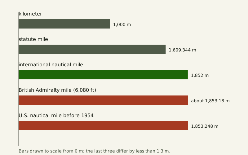
Figure: The Yardstick Almanac, CC BY 4.0
Credit line to copy
"The nautical mile against the kilometer, the statute mile and two older nautical miles" by The Yardstick Almanac, https://theyardstickalmanac.com/units/nautical-mile/, licensed under CC BY 4.0 (https://creativecommons.org/licenses/by/4.0/).
Data: Values from U.S. government publications (NBS SP 447, NIST Handbook 44, NIST SP 811, 24 FR 5348; public domain) and the BIPM SI Brochure, 9th ed. V4.01 (CC BY 4.0; adapted: values restated, not the table); compiled and partly computed 2026-11-01, CC BY 4.0
Where does 1,852 m come from?
National nautical miles used to differ. A 1954 bulletin from the National Bureau of Standards, reprinted in NBS Special Publication 447, says “The British and the U.S. nautical miles were each derived by taking 60 nautical miles per degree, but the values adopted were not the same.” The British Admiralty used 6,080 British feet, about 1,853.18 m by our conversion. The U.S. value was 1,853.248 m [exact by definition], or about 6,080.20 U.S. feet.
The U.S. figure has a stated recipe. An 1894 table from the Office of Standard Weights and Measures, also reprinted in SP 447, defines the Coast Survey nautical mile as “the length of a minute of arc of a great circle of a sphere whose surface is equal to the surface of the earth (the Clarke spheroid of 1866)” and prints 1853.25 metres. We recomputed it. A sphere with the surface area of the Clarke 1866 ellipsoid has a radius of about 6,370,997 m, and one minute of arc on it is 1,853.248 m (rounded) [exact by definition], the 1954 value to the millimeter.
In 1929, the same bulletin says, the International Hydrographic Bureau won agreement from many countries on 1,852 m. Great Britain, the U.S.S.R. and the United States did not accept it then. None of the documents we read explains how 1,852 was picked, so this page does not claim it was an average.
The United States moved in 1954. In 1953 an informal Defense and Commerce group expressed the belief that the change “would not affect nautical charts, the calibration of navigational instruments, or navigation.” By directives of the Commerce and Defense departments, 1,852 m replaced 1,853.248 m within those departments from July 1, 1954, as the 1954 bulletin, 24 FR 5348 and NIST Handbook 44 record. The yard and pound got their exact metric values five years later, the story told in the metric system in the U.S.
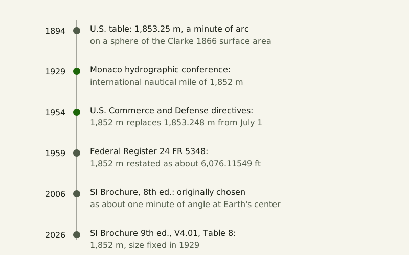
Figure: The Yardstick Almanac, CC BY 4.0
Credit line to copy
"The documents behind the nautical mile, 1894 to 2026" by The Yardstick Almanac, https://theyardstickalmanac.com/units/nautical-mile/, licensed under CC BY 4.0 (https://creativecommons.org/licenses/by/4.0/).
Data: Values from U.S. government publications (NBS SP 447, NIST Handbook 44, NIST SP 811, 24 FR 5348; public domain) and the BIPM SI Brochure, 9th ed. V4.01 (CC BY 4.0; adapted: values restated, not the table); compiled and partly computed 2026-11-01, CC BY 4.0
| Year | Document | What it says |
|---|---|---|
| 1894 | U.S. conversion tables (SP 447, App. 3) | Coast Survey nautical mile: a minute of arc on a Clarke 1866 equal-area sphere, 1853.25 m |
| 1929 | 1st Extraordinary International Hydrographic Conference, Monaco | International nautical mile of 1,852 m |
| 1954 | Commerce and Defense directives (SP 447, App. 4) | 1,852 m replaces 1,853.248 m in those departments from July 1 |
| 1959 | 24 FR 5348 | 1,852 m is about 6,076.11549 international feet |
| 2006 | SI Brochure, 8th edition, Table 8 note (d) | The unit was chosen for about one minute of angle at Earth's center |
| 2026 | SI Brochure, 9th edition V4.01, Table 8 note (k) | Size defined by the 1929 conference; no agreed symbol |
Why does a minute of latitude change length?
Earth's meridians are not circles. On an ellipsoid, latitude is the angle between the line perpendicular to the surface and the plane of the equator, so a minute of latitude is the ground you cross while that line tilts by 1′. Near the equator the meridian curves more tightly, with a radius of about 6,335 km on the WGS 84 ellipsoid; near the poles it is flatter, about 6,400 km. The same 1′ turn covers less ground on the tight curve.
We used the WGS 84 constants a = 6,378,137 m and 1/f = 298.257223563 from the PROJ source code, which match NGA's TR8350.2. We computed every whole degree two ways, once from the curvature formula and once as a geodesic distance with the pyproj library. The two methods agree to under 1 cm.
| Latitude | One minute of latitude | Minus 1,852 m |
|---|---|---|
| 0° | 1,842.90 m | −9.10 m |
| 15° | 1,844.14 m | −7.86 m |
| 30° | 1,847.54 m | −4.46 m |
| 45° | 1,852.20 m | +0.20 m |
| 60° | 1,856.87 m | +4.87 m |
| 75° | 1,860.31 m | +8.31 m |
| 90° | 1,861.57 m | +9.57 m |
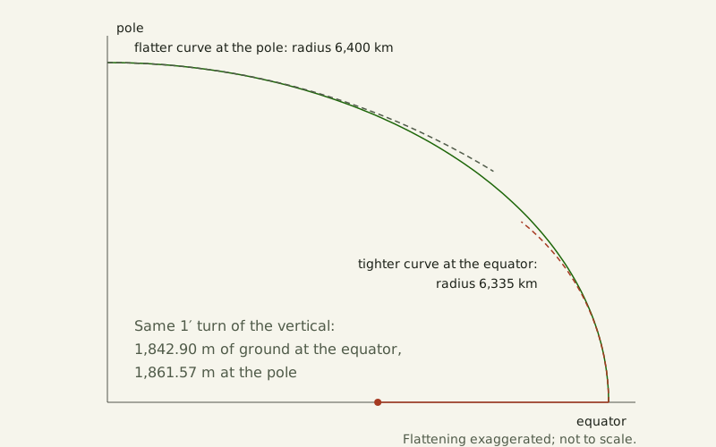
Figure: The Yardstick Almanac, CC BY 4.0
Credit line to copy
"Why a minute of latitude is shorter at the equator than at the pole" by The Yardstick Almanac, https://theyardstickalmanac.com/units/nautical-mile/, licensed under CC BY 4.0 (https://creativecommons.org/licenses/by/4.0/).
Data: Computed 2026-11-01 from the WGS 84 constants in PROJ 9.8.1 src/ellps.cpp (MIT license) and the 1852 m definition in the BIPM SI Brochure, 9th ed. V4.01 (CC BY 4.0; adapted: the defined value used in new calculations); CC BY 4.0
A sphere gives a slightly different minute. On a sphere with the WGS 84 surface area, the same kind of sphere behind the old U.S. mile, one minute of arc is 1,853.25 m (rounded) [exact by definition]. Turning an angle into ground distance is also the step behind Eratosthenes' Earth circumference.
Why do ships and planes count in nautical miles?
The current SI Brochure says only that the nautical mile and the knot “are used in marine and aerial navigation to express distance and speed, respectively.” The 2006 edition gave a reason: “The unit was originally chosen, and continues to be used, because one nautical mile on the surface of the Earth subtends approximately one minute of angle at the centre of the Earth, which is convenient when latitude and longitude are measured in degrees and minutes of angle.” Version 4.01 of the 9th edition keeps the 1929 fact but not that sentence.
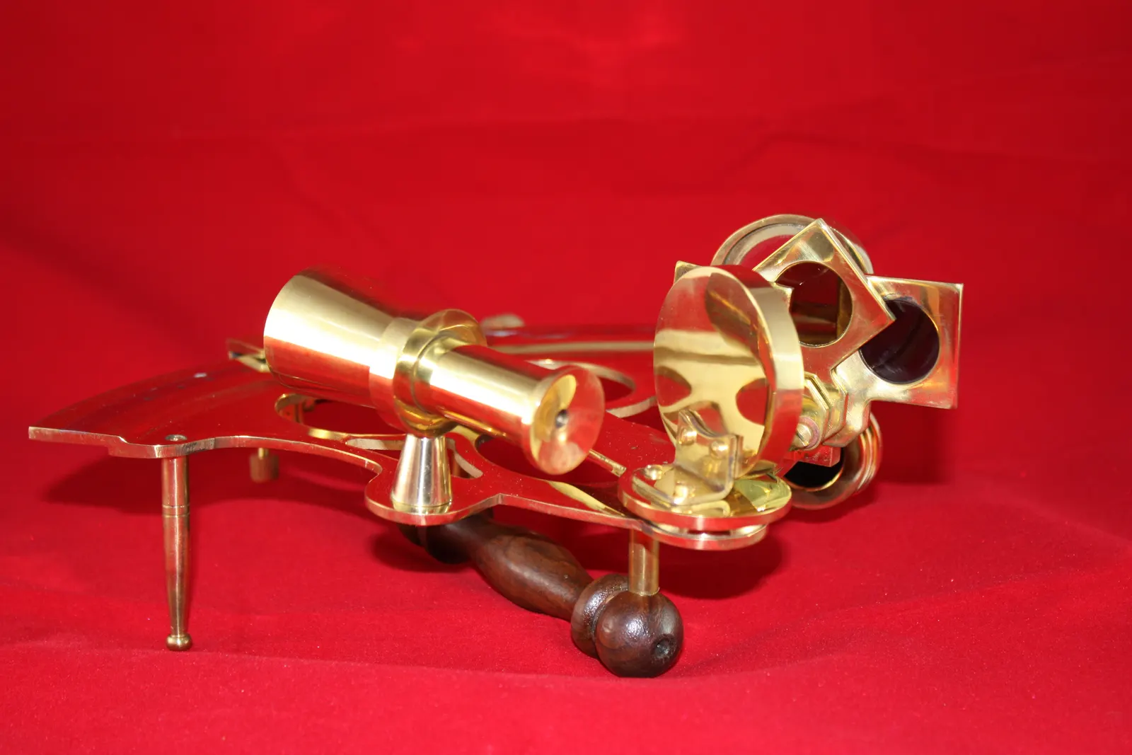
"Sextant (NPS Photo, Lewis and Clark National Historical Park)" by NPS Photo, public domain
Full credit
"Sextant (NPS Photo, Lewis and Clark National Historical Park)" by NPS Photo — https://commons.wikimedia.org/wiki/File:This_instrument_was_used_to_measure_the_angular_distance_between_the_moon_and_sun_or_a_star_for_determining_longitude._(1d68d331-1dd8-b71b-0bf5-2e79f90f1e7b).JPG — Public domain (work of the U.S. federal government, 17 U.S.C. §105 (Commons tag PD-USGov-NPS: material based on a work of a National Park Service employee created as part of official duties; photographer field NPS Photo, publisher U.S. National Park Service, source NPGallery); structured data: public domain in the United States, work of the federal government)
Our table shows how close the match is for latitude. Anywhere from the equator to the pole, one minute of latitude stays within 0.52 percent of a nautical mile: 0.49 percent short at the equator and 0.52 percent long at the poles. A minute of longitude does not work this way, because it shrinks toward the poles.
Sources
- Bureau International des Poids et Mesures, The International System of Units (SI), 9th edition (2019), version 4.01 (June 2026), DOI 10.59161/AUEZ1291. Section 4 and Table 8, “Non-SI units” (pp. 140–141), note (k) (p. 141). https://www.bipm.org/documents/20126/41483022/SI-Brochure-9-EN.pdf Read: section 4, Table 8 and its notes Text license: CC BY 4.0
- Bureau International des Poids et Mesures, The International System of Units (SI), 8th edition (2006). Table 6, note (b) (p. 124); Table 8, “Other non-SI units,” notes (d) and (f) (p. 127). https://www.bipm.org/documents/20126/41483022/si_brochure_8.pdf/632d85cd-cd9f-cfae-21d2-9ffcfc2bb198?version=1.7&t=1756803067749&download=true Read: Tables 6 and 8 with their notes (bilingual PDF, English part)
- Ambler Thompson and Barry N. Taylor, Guide for the Use of the International System of Units (SI), NIST Special Publication 811, 2008 edition. Sec. 5.2 and Table 9; Appendix B.8 with footnote 20. https://nvlpubs.nist.gov/nistpubs/Legacy/SP/nistspecialpublication811e2008.pdf Read: Table 9 and Appendix B.8 entries for the nautical mile and knot, footnote 20
- Lewis V. Judson, Weights and Measures Standards of the United States, A Brief History, NBS Special Publication 447 (National Bureau of Standards, 1963, updated 1976). Appendix 3 (conversion tables of the Office of Standard Weights and Measures, March 21, 1894), p. 29; Appendix 4, “The International Nautical Mile” (NBS Technical News Bulletin, August 1954), pp. 29–30. https://nvlpubs.nist.gov/nistpubs/Legacy/SP/nbsspecialpublication447.pdf Read: Appendices 3 and 4 in full
- National Bureau of Standards and U.S. Coast and Geodetic Survey, “Refinement of Values for the Yard and the Pound,” Federal Register 24, no. 128 (July 1, 1959), 5348–5349 (24 FR 5348), F.R. Doc. 59-5442, paragraph “Nautical mile.” https://www.govinfo.gov/content/pkg/FR-1959-07-01/pdf/FR-1959-07-01.pdf Read: full notice (paragraph on the nautical mile used here)
- National Institute of Standards and Technology, NIST Handbook 44 – 2026, Appendix C, General Tables of Units of Measurement, sections 2 and 5 and note 21. DOI 10.6028/NIST.HB.44-2026. https://www.nist.gov/document/2026-nist-handbook-44-appendix-c Read: sections 2 and 5 and note 21
- PROJ contributors, PROJ 9.8.1, src/ellps.cpp (ellipsoid table: WGS84 a = 6378137.0, rf = 298.257223563; clrk66 a = 6378206.4, b = 6356583.8). MIT license. The WGS 84 values correspond to NGA TR8350.2. https://github.com/OSGeo/PROJ/blob/9.8.1/src/ellps.cpp Read: full file
- Wikimedia Commons, File:This instrument was used to measure the angular distance between the moon and sun or a star for determining longitude. (1d68d331-1dd8-b71b-0bf5-2e79f90f1e7b).JPG (NPS Photo, Lewis and Clark National Historical Park, 2017; from NPGallery). https://commons.wikimedia.org/wiki/File:This_instrument_was_used_to_measure_the_angular_distance_between_the_moon_and_sun_or_a_star_for_determining_longitude._(1d68d331-1dd8-b71b-0bf5-2e79f90f1e7b).JPG Read: full file description

Data files (computed 2026-11-01 on the WGS 84 ellipsoid with constants from PROJ 9.8.1, two ways: the meridian radius of curvature and geodesic distances from pyproj 3.8.0, MIT license; conversions with exact fractions, checked against the values printed by NIST and the Federal Register; each file comes with a notes file giving its sources and license):
- One minute of latitude on WGS 84, every degree from 0° to 90° (CSV, source and license notes) Data: Computed 2026-11-01 from the WGS 84 constants in PROJ 9.8.1 src/ellps.cpp (MIT license) and the 1852 m definition in the BIPM SI Brochure, 9th ed. V4.01 (CC BY 4.0; adapted: the defined value used in new calculations); CC BY 4.0
- Nautical mile definitions and values, 1894 to 1959 (CSV, source and license notes) Data: Values from U.S. government publications (NBS SP 447, NIST Handbook 44, NIST SP 811, 24 FR 5348; public domain) and the BIPM SI Brochure, 9th ed. V4.01 (CC BY 4.0; adapted: values restated, not the table); compiled and partly computed 2026-11-01, CC BY 4.0
Cite this page
The Yardstick Almanac. "Nautical Mile: 1,852 m, While a Minute of Latitude Varies." Published November 1, 2026. https://theyardstickalmanac.com/units/nautical-mile/. Accessed [the date you read it].
More in Units & Standards
Units & Standards
U.S. Survey Foot: America Had Two Official Feet Until 2023
Image credit
"Measuring base with Invar tape, Stanfield, Oregon (NOAA Photo Library theb1656)" by U.S. Coast and Geodetic Survey — https://commons.wikimedia.org/wiki/File:Theb1656_-_Flickr_-_NOAA_Photo_Library.jpg — Public domain (work of the U.S. federal government, 17 U.S.C. §105; also released by the NOAA Photo Library under CC BY 2.0)
Units & Standards
Kilogram Definition: Why the 1889 Cylinder Has Uncertainty
Image credit
"K20 and Friends: four of the five U.S. national prototype kilogram artifacts, including K20 (front) and K4 (back)" by J. Lee/NIST — https://commons.wikimedia.org/wiki/File:Kilograms-pml0013_K20_and_Friends_Four_of_the_five_U.S._national_prototype_kilogram_artifacts,_including_K20_(front)_and_K4_(back).png — Public domain (work of the U.S. federal government, 17 U.S.C. §105 (photograph by J. Lee of NIST, published by NIST in 2018); Commons also marks the file with the Public Domain Mark 1.0)
Units & Standards
Metric System in the U.S.: The Yard Is Defined by the Meter
Image credit
"Committee Meter Bar, made of platinum in 1799 (NIST Museum Collection)" by NIST Museum Collection — https://commons.wikimedia.org/wiki/File:Committee_Meter_Bar_Platinum_1799.png — Public domain (work of the U.S. federal government, 17 U.S.C. §105 (photograph from the NIST Museum Collection, source https://www.nist.gov/image/committee-meter); Commons also marks the file with the Public Domain Mark 1.0)
How this page is checked: Where the numbers come from explains the value tags, the source order and how every figure is recomputed.
Corrections: every substantive change is logged in What we got wrong.
Spotted an error? Email contact@theyardstickalmanac.com with the sentence and your source, or read Write in first.