WGS 84: The Same Coordinates Can Land Meters Apart
The Yardstick Almanac Published No substantive revisions
Short answer
A latitude-longitude pair marks one spot only once a datum is named: read as NAD 27 instead of NAD 83, sampled lower-48 points land 1.0 to 100.5 m apart.
Station index 5 sections
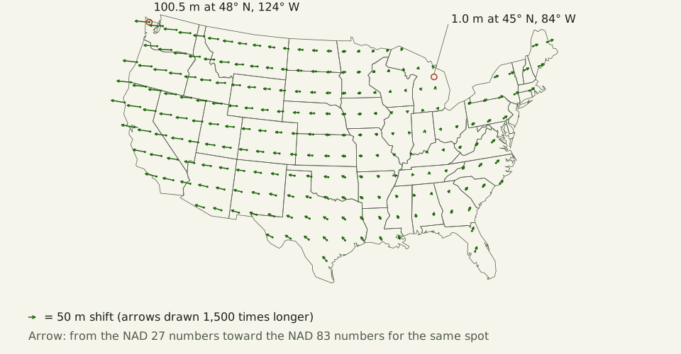
Figure: The Yardstick Almanac, CC BY 4.0
Credit line to copy
"NAD 27 to NAD 83 shift across the lower 48 states" by The Yardstick Almanac, https://theyardstickalmanac.com/maps/wgs-84/, licensed under CC BY 4.0 (https://creativecommons.org/licenses/by/4.0/).
Data: National Geodetic Survey, NADCON5 grids nad27.nad83_1986.conus (release 20160901), public domain; Natural Earth 1:50m Admin 1 – States, Provinces, version 5.1.2, public domain; Projection: Albers equal-area conic on GRS 80, standard parallels 29.5° N and 45.5° N, origin 23° N, 96° W; 2026-11-01, CC BY 4.0
Across the lower 48, one latitude-longitude pair read in two U.S. datums can mark spots up to 100.5 m apart. The two datums are the North American Datum of 1927 (NAD 27) and its 1983 successor (NAD 83). The shift comes from NADCON5, the National Geodetic Survey's transformation grids in their September 2016 release, which we sampled at 823 whole-degree points inside state lines. WGS 84, the frame GPS receivers compute in, is a third choice, and this page is about the gaps between all three.
WGS 84 is the World Geodetic System 1984: a reference ellipsoid placed in an Earth-centered frame. Its ellipsoid is defined by a semi-major axis of 6,378,137 m and an inverse flattening of 298.257223563 [exact by definition]. Those are the values coded in the PROJ library's source, corresponding to the National Geospatial-Intelligence Agency's document TR8350.2. A coordinate pair without its datum name is not wrong, only unfinished.
What is a datum, and what does WGS 84 fix?
The National Geodetic Survey (NGS) defines a geodetic datum as “an abstract coordinate system with a reference surface (such as sea level) that serves to provide known locations to begin surveys and create maps.” For latitude and longitude, the reference surface is an ellipsoid, a sphere squashed slightly at the poles. A datum fixes the ellipsoid's size and flattening, and where its center and axes sit relative to the solid Earth.
WGS 84 sets its equatorial radius at 6,378,137 m and its flattening at 1/298.257223563 [exact by definition]. That makes the polar radius 6,356,752.314 m (rounded) [exact by definition], about 21.4 km shorter. Change either number, or move the center, and most spots on the ground get a new latitude, a new longitude or both.
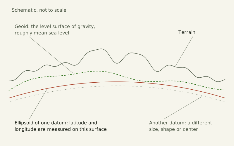
Figure: The Yardstick Almanac, CC BY 4.0
Credit line to copy
"Terrain, geoid and ellipsoid" by The Yardstick Almanac, https://theyardstickalmanac.com/maps/wgs-84/, licensed under CC BY 4.0 (https://creativecommons.org/licenses/by/4.0/).
Data: Schematic drawing, no data; 2026-11-01, CC BY 4.0
The ellipsoid is not sea level. The geoid, which NGS calls “a rough estimate of global mean sea level,” rises and falls against it, and the ground rises and falls again above that. Heights above sea level need the geoid. Latitude and longitude need only the ellipsoid and its placement, which is why two datums can disagree about a spot without anyone measuring it wrong.
Why do NAD 27, NAD 83 and WGS 84 disagree?
Each one picked a different ellipsoid. In the EPSG Geodetic Parameter Dataset, the registry of datums and transformations that ships with PROJ, NAD 27 uses Clarke 1866, NAD 83 uses GRS 80, and WGS 84 uses its own.
| Ellipsoid | Used by | Equatorial radius a | Inverse flattening 1/f | Polar radius b, vs WGS 84 |
|---|---|---|---|---|
| Clarke 1866 | NAD 27 | 6,378,206.4 m | 294.979 (from a and b) | 168.5 m shorter |
| GRS 80 | NAD 83 | 6,378,137 m | 298.257222101 | 0.10 mm shorter |
| WGS 84 | WGS 84 | 6,378,137 m | 298.257223563 | (reference) |
Clarke 1866 has an equatorial radius 69.4 m longer than WGS 84 and a polar radius 168.5 m shorter (rounded) [exact by definition]. GRS 80 and WGS 84 have the same equatorial radius and first differ in the ninth significant digit of 1/f. That moves the polar radius by 0.10 mm (rounded) [exact by definition].
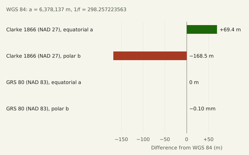
Figure: The Yardstick Almanac, CC BY 4.0
Credit line to copy
"Three ellipsoids compared with WGS 84" by The Yardstick Almanac, https://theyardstickalmanac.com/maps/wgs-84/, licensed under CC BY 4.0 (https://creativecommons.org/licenses/by/4.0/).
Data: PROJ 9.8.1 src/ellps.cpp (WGS 84, GRS 80 and Clarke 1866 ellipsoids; WGS 84 values from NGA TR8350.2), MIT license; EPSG Geodetic Parameter Dataset v12.029, as distributed with PROJ 9.8.1 (transformations 1188 and 8555, datum ensemble 6326); 2026-11-01, CC BY 4.0
The ellipsoid is only part of it. NGS says NAD 83 “is misaligned to the earth’s center by about 2.2 meters” [measured, source gives no uncertainty], and the same page puts the current NAD 83 frames off the latest international estimates of the center “by two to four meters (depending on the frame).” WGS 84 is built around that center: the GPS performance standard calls it an “Earth-Centered, Earth-Fixed” coordinate system.
How far apart do the same numbers land?
We took every whole-degree point inside the outlines of the 48 conterminous states and Washington, D.C., 823 points in all; the outlines take in each state's share of the Great Lakes, so some points sit on open water. We treated each as a NAD 27 coordinate pair and computed its shift to NAD 83 with the NADCON5 grids twice: once by reading the NGS grid files and interpolating the way the NGS code does, and once with the PROJ library through pyproj 3.8.0. The two results agree to well under a millimeter. EPSG lists the grid's accuracy as 0.15 m onshore at a 67% confidence level.
The shifts run from 1.0 m at 45° N, 84° W in Michigan to 100.5 m at 48° N, 124° W in Washington. The median is 36.0 m. They are largest in the west: the median is 89 m at or west of 117° W, 30 m between 94° and 102° W, and 38 m at or east of 75° W.
| Point | State | Moves north (m) | Moves east (m) | Shift (m) |
|---|---|---|---|---|
| 47° N, 122° W | Washington | −19.0 | −93.2 | 95.1 |
| 38° N, 122° W | California | −8.7 | −94.2 | 94.6 |
| 34° N, 118° W | California | 1.3 | −82.8 | 82.8 |
| 39° N, 98° W | Kansas | 0.6 | −28.2 | 28.2 |
| 30° N, 90° W | Louisiana | 22.4 | −6.7 | 23.4 |
| 27° N, 81° W | Florida | 36.9 | 21.1 | 42.5 |
| 42° N, 71° W | Massachusetts | 11.3 | 42.4 | 43.9 |
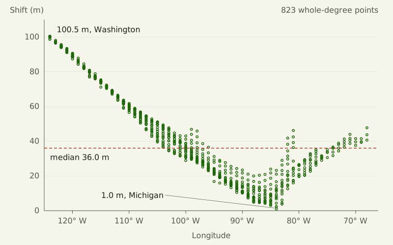
Figure: The Yardstick Almanac, CC BY 4.0
Credit line to copy
"NAD 27 to NAD 83 shift by longitude" by The Yardstick Almanac, https://theyardstickalmanac.com/maps/wgs-84/, licensed under CC BY 4.0 (https://creativecommons.org/licenses/by/4.0/).
Data: National Geodetic Survey, NADCON5 grids nad27.nad83_1986.conus (release 20160901), public domain; 2026-11-01, CC BY 4.0
In coordinate terms, the 100.5 m at the Washington point is 0.70 seconds of latitude and 4.74 seconds of longitude. On WGS 84, one minute of latitude runs from 1,843 m at the equator to 1,862 m at the poles (both rounded) [exact by definition], a range you can hold the nautical mile up against. A thousandth of a degree of latitude is 111 m at 45° N (rounded) [exact by definition], so the whole disagreement hides in the third decimal place of a coordinate written in degrees.
On a national map it vanishes. At 1:20,000,000, the scale the county boundaries behind this site's choropleth maps were made for, 100 m is 0.005 mm on paper [exact by definition].
Where does GPS get its coordinates?
GPS receivers compute in WGS 84. The GPS Standard Positioning Service Performance Standard (5th edition, April 2020) assumes a receiver that does its satellite position computations “in the most current realization of the World Geodetic System 1984 (WGS 84).” A realization is one version of the frame. The EPSG dataset (version 12.029) lists eight: the original Transit realization of 1984, then G730, G873, G1150, G1674, G1762, G2139 and G2296, the last with a frame epoch of 2024.0.
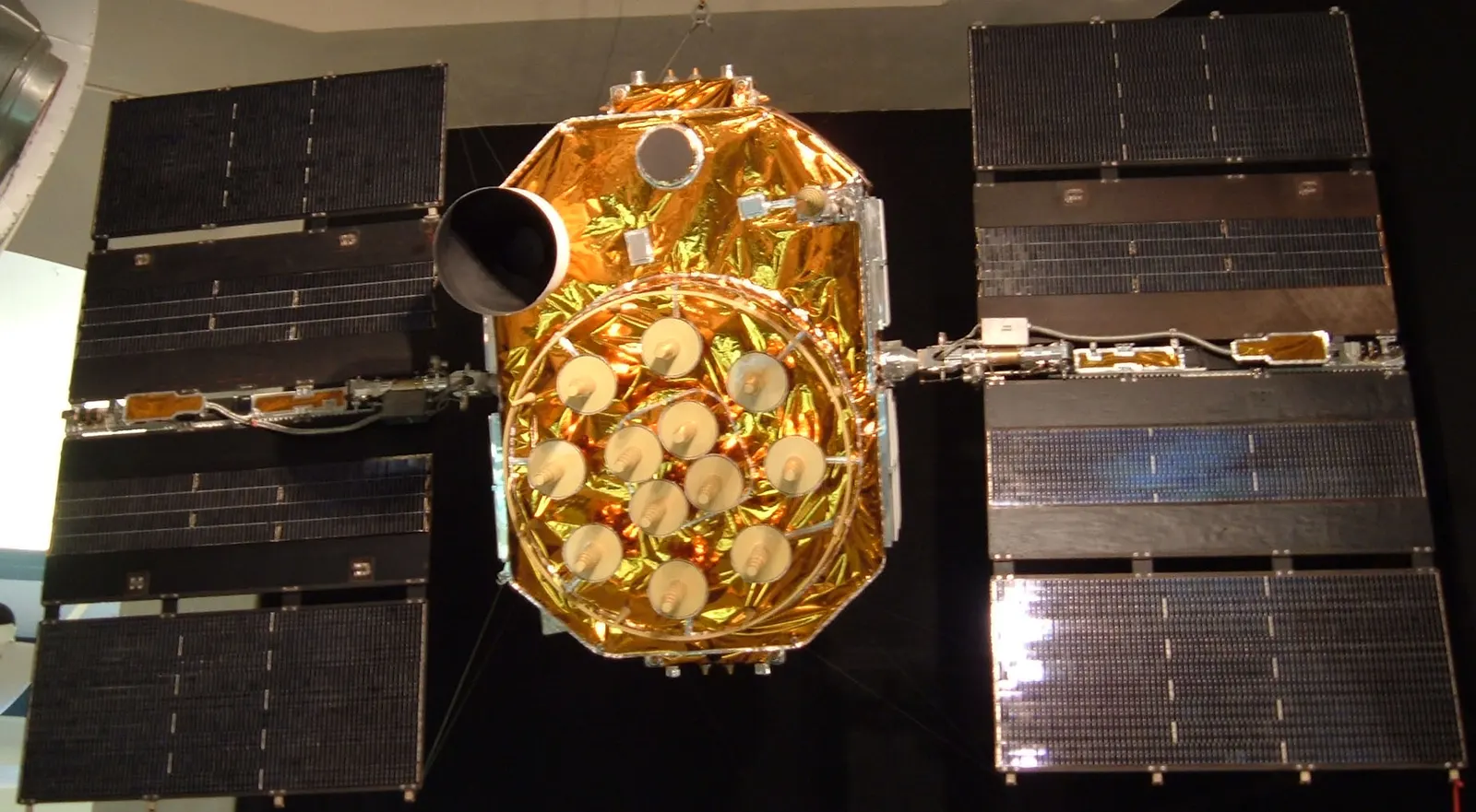
"Global Positioning System satellite" by Scott Ehardt, public domain
Full credit
"Global Positioning System satellite" by Scott Ehardt — https://commons.wikimedia.org/wiki/File:Global_Positioning_System_satellite.jpg — Public domain (Author dedication, not term expiry: the photographer, Scott Ehardt, released this own work (uploaded 2 June 2005) into the public domain worldwide on the Commons file page, so it holds in the United States and in the EU alike; where a dedication is not legally possible, his fallback grant lets anyone use the work for any purpose without conditions. The photographed object is an unlaunched GPS Block II-A satellite, a utilitarian spacecraft on museum display, not a separate artwork.)
Because those realizations differ slightly, EPSG treats WGS 84 as one ensemble with an accuracy of 2 m. The standard NAD 83 to WGS 84 step in the same dataset, transformation 1188, moves coordinates by 0 m and carries a stated accuracy of 4 m; its note says it was “Derived at 354 stations.” In our run, pyproj picked that zero step by default. Software that follows it reports the same 1.0 to 100.5 m for NAD 27 against WGS 84 as for NAD 27 against NAD 83.
For an ordinary GPS receiver, the smaller gap is easy to lose in the noise. The performance standard sets a global average of no more than 8 m of horizontal error, 95% of the time, and notes that well-designed receivers were achieving 3 m or better as of 2018. The NAD 83 offset NGS describes, about 2.2 m, is under 8 m, though it is an offset of the frame's center, not a shift measured at any one spot. At most sampled points a NAD 27 pair read as WGS 84 stands out: the median shift in our sample, 36.0 m, is more than four times that 8 m limit.
What changes next in the U.S.?
NGS plans to retire NAD 83. As of November 2026, its New Datums page says NGS will replace all three NAD 83 frames with four new ones, each “mathematically defined relative to the International Terrestrial Reference Frame of 2020 (ITRF2020)” and named for a tectonic plate: NATRF2022, PATRF2022, CATRF2022 and MATRF2022. Fixing NAD 83 and the vertical datum NAVD 88 will change every published U.S. latitude, longitude and height “by as much as four meters,” the page says.
The State Plane Coordinate System of 2022 (SPCS2022) keeps its grid numbers well apart from older grids. Its policy, effective July 1, 2023, requires SPCS2022 coordinates to “differ by at least 10,000 m horizontally” from SPCS 83, SPCS 27 and every version of UTM covering the same area. A grid coordinate read in the wrong system then lands roughly 10 km or more from the right spot. The policy bases every projection on GRS 80, not on the WGS 84 ellipsoid, and supports the U.S. survey foot only in older systems.
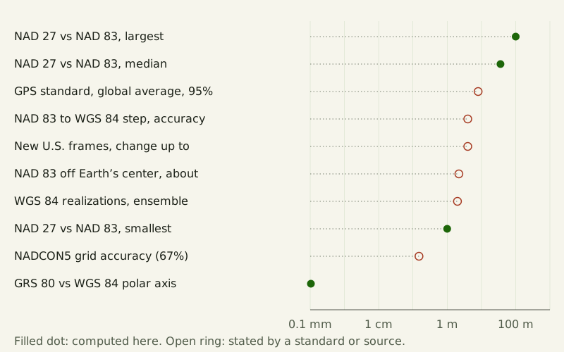
Figure: The Yardstick Almanac, CC BY 4.0
Credit line to copy
"Datum gaps and accuracies on one scale" by The Yardstick Almanac, https://theyardstickalmanac.com/maps/wgs-84/, licensed under CC BY 4.0 (https://creativecommons.org/licenses/by/4.0/).
Data: National Geodetic Survey, NADCON5 grids nad27.nad83_1986.conus (release 20160901), public domain; GPS Standard Positioning Service Performance Standard, 5th edition (April 2020); EPSG Geodetic Parameter Dataset v12.029, as distributed with PROJ 9.8.1 (transformations 1188 and 8555, datum ensemble 6326); National Geodetic Survey, New Datums web page (read 2026-11-01); PROJ 9.8.1 src/ellps.cpp (WGS 84, GRS 80 and Clarke 1866 ellipsoids; WGS 84 values from NGA TR8350.2), MIT license; 2026-11-01, CC BY 4.0
| Difference or accuracy | Size | Kind |
|---|---|---|
| NAD 27 vs NAD 83, largest in our sample | 100.5 m | computed |
| NAD 27 vs NAD 83, median | 36.0 m | computed |
| GPS civil service, global-average 95% horizontal error, at most | 8 m | performance standard |
| NAD 83 to WGS 84 zero step, stated accuracy | 4 m | EPSG 1188 |
| New U.S. frames, change to coordinates and heights | as much as 4 m | NGS |
| NAD 83 off Earth's center | about 2.2 m | NGS |
| WGS 84 realizations as one ensemble | 2 m | EPSG |
| NAD 27 vs NAD 83, smallest in our sample | 1.0 m | computed |
| NADCON5 grid, onshore, 67% confidence | 0.15 m | EPSG 8555 |
| GRS 80 vs WGS 84, polar radius | 0.10 mm | computed |
Sources
- PROJ contributors, PROJ 9.8.1, src/ellps.cpp (ellipsoid table: WGS84 a = 6378137.0, rf = 298.257223563; GRS80 a = 6378137.0, rf = 298.257222101; clrk66 a = 6378206.4, b = 6356583.8). MIT license. WGS 84 values correspond to NGA TR8350.2. https://github.com/OSGeo/PROJ/blob/9.8.1/src/ellps.cpp Read: full file
- IOGP, EPSG Geodetic Parameter Dataset, version 12.029 (2025-10-02), as distributed in proj.db with PROJ 9.8.1 (pyproj 3.8.0): transformation 1188 “NAD83 to WGS 84 (1)”, transformation 8555 “NAD27 to NAD83 (7)”, datum ensemble 6326 “World Geodetic System 1984 ensemble”, datums 6267 and 6269. https://epsg.org Read: records 1188, 8555, 6326 (with its eight members), 6267, 6269, 7008, 7019, 7030
- National Geodetic Survey, NADCON5, release 20160901: grids nadcon5.nad27.nad83_1986.conus.lat.trn.20160901.b and .lon.trn.20160901.b, and interpolation routines biquad.f and qterp.f. https://geodesy.noaa.gov/pub/nadcon5/20160901release/Builds/nad27.nad83_1986.conus/ Read: full grid files; interpolation routines in full
- U.S. Department of Defense, Global Positioning System Standard Positioning Service Performance Standard, 5th edition, April 2020, sections 3.8 and 3.8.3, Table 3.8-3. https://www.gps.gov/sites/default/files/2025-07/2020-SPS-performance-standard.pdf Read: foreword, introduction and section 3.8
- National Geodetic Survey, “New Datums: Replacing NAVD 88 and NAD 83.” https://geodesy.noaa.gov/datums/newdatums/index.shtml Read: full page
- National Geodetic Survey, “Datums and Reference Frames.” https://geodesy.noaa.gov/datums/index.shtml Read: full page (overview text)
- National Geodetic Survey, State Plane Coordinate System of 2022 Policy, NGS 2023-1214-03, effective July 1, 2023, sections I.D, II.B and II.E. https://geodesy.noaa.gov/INFO/Policy/files/SPCS2022-Policy.pdf Read: full document (8 pages)
- PROJ-data, us_noaa_nadcon5_nad27_nad83_1986_conus.tif (NADCON5 NAD27 to NAD83 grid converted to GeoTIFF; interpolation_method biquadratic). Public domain. https://cdn.proj.org/us_noaa_nadcon5_nad27_nad83_1986_conus.tif Read: full file (used by PROJ)
- Natural Earth, 1:50m Cultural Vectors, Admin 1 – States, Provinces, version 5.1.2. Public domain. https://github.com/nvkelso/natural-earth-vector/tree/v5.1.2 Read: full dataset (U.S. state polygons only)
Data files (NAD 27 to NAD 83 shifts computed two ways from the NGS NADCON5 grids, public domain, with pyproj 3.8.0 and PROJ 9.8.1, MIT license; ellipsoid values from the PROJ source and the EPSG dataset; each file comes with a notes file giving its sources and license):
- NAD 27 to NAD 83 shift at 823 points (CSV, source and license notes) Data: National Geodetic Survey, NADCON5 grids nad27.nad83_1986.conus (release 20160901), public domain; PROJ-data us_noaa_nadcon5_nad27_nad83_1986_conus.tif (the same NADCON5 grid), public domain; EPSG Geodetic Parameter Dataset v12.029, as distributed with PROJ 9.8.1 (transformations 1188 and 8555, datum ensemble 6326); Natural Earth 1:50m Admin 1 – States, Provinces, version 5.1.2, public domain; computed 2026-11-01, CC BY 4.0
- Clarke 1866, GRS 80 and WGS 84 ellipsoids (CSV, source and license notes) Data: PROJ 9.8.1 src/ellps.cpp (WGS 84, GRS 80 and Clarke 1866 ellipsoids; WGS 84 values from NGA TR8350.2), MIT license; EPSG Geodetic Parameter Dataset v12.029, as distributed with PROJ 9.8.1 (transformations 1188 and 8555, datum ensemble 6326); computed 2026-11-01, CC BY 4.0
- Datum gaps and accuracies, with sources (CSV, source and license notes) Data: National Geodetic Survey, NADCON5 grids nad27.nad83_1986.conus (release 20160901), public domain; GPS Standard Positioning Service Performance Standard, 5th edition (April 2020); EPSG Geodetic Parameter Dataset v12.029, as distributed with PROJ 9.8.1 (transformations 1188 and 8555, datum ensemble 6326); National Geodetic Survey, New Datums web page (read 2026-11-01); PROJ 9.8.1 src/ellps.cpp (WGS 84, GRS 80 and Clarke 1866 ellipsoids; WGS 84 values from NGA TR8350.2), MIT license; computed 2026-11-01, CC BY 4.0
Cite this page
The Yardstick Almanac. "WGS 84: The Same Coordinates Can Land Meters Apart." Published November 1, 2026. https://theyardstickalmanac.com/maps/wgs-84/. Accessed [the date you read it].
More in Maps Explained
Maps Explained
Prime Meridian: The 1884 Vote Named a Telescope, Not a Mark
Image credit
"The Royal Observatory, Greenwich Hill, top, and the view of Greenwich and London seen from the hill, below" by Wellcome Collection — https://commons.wikimedia.org/wiki/File:The_Royal_Observatory,_Greenwich_Hill,_top,_and_the_view_of_Wellcome_V0013355.jpg — CC BY 4.0 (https://creativecommons.org/licenses/by/4.0/)
Maps Explained
Choropleth Map: Raw Counts Mostly Redraw the Population Map
Image credit
"1940 Census Enumeration" by U.S. Census Bureau — https://commons.wikimedia.org/wiki/File:1940_Census_Enumeration_(5020520332).jpg — Public domain (work of the U.S. federal government, 17 U.S.C. §105: the Commons file page tags it as the work of a United States Census Bureau employee made as part of official duties; also released by the U.S. Census Bureau on Flickr under CC BY 2.0, which is the basis used outside the United States)
How this page is checked: Where the numbers come from explains the value tags, the source order and how every figure is recomputed.
Corrections: every substantive change is logged in What we got wrong.
Spotted an error? Email contact@theyardstickalmanac.com with the sentence and your source, or read Write in first.