Prime Meridian: The 1884 Vote Named a Telescope, Not a Mark
The Yardstick Almanac Published No substantive revisions
Short answer
The 1884 International Meridian Conference proposed as longitude zero the meridian through the center of the transit instrument at Greenwich Observatory: a telescope, not a line on the ground.
Station index 8 sections
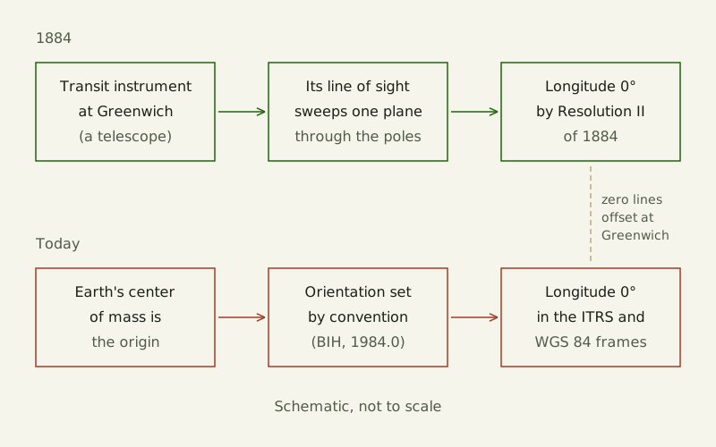
Figure: The Yardstick Almanac, CC BY 4.0
Credit line to copy
"How longitude zero was fixed in 1884 and today" by The Yardstick Almanac, https://theyardstickalmanac.com/maps/prime-meridian/, licensed under CC BY 4.0 (https://creativecommons.org/licenses/by/4.0/).
Data: International Meridian Conference protocols (1884), public domain; IERS Conventions (2010) ch. 4; 2026-11-01, CC BY 4.0
In 1884, longitude zero was tied to one telescope at Greenwich, not to a line painted on the ground. The protocols of the International Meridian Conference list delegates from 26 nations, who met in Washington that October and on October 13 voted for “the meridian passing through the transit instrument at the Observatory of Greenwich.” The Final Act of October 22 records the result as 22 for, 1 against and 2 abstaining. That was a choice. The satellite-era reference frames later made a different one, and their zero no longer runs through the instrument.
The prime meridian is the line of longitude 0°, the starting point for counting east and west. Since that 1884 conference it has been the Greenwich meridian. A second resolution set how to count from it: longitude runs “in two directions up to 180 degrees, east longitude being plus and west longitude minus.” That one passed 14 to 5, with 6 abstentions.
What did the 1884 resolution say?
The Final Act gives Resolution II in one sentence. The conference proposed to the governments represented “the adoption of the meridian passing through the centre of the transit instrument at the Observatory of Greenwich as the initial meridian for longitude.” The anchor is the center of an instrument inside a building, not a mark on the ground.
A transit instrument is a telescope mounted to swing in a single plane, used to time stars as they cross fine wires in its field of view. Edward Walter Maunder's 1900 book on the observatory describes the one at Greenwich, set between two great stone pillars. “It turns but in one plane, that of ‘longitude nought,’” he wrote, and elsewhere: “The optical axis of this telescope marks ‘Longitude Nought.’”
The vote left two slightly different records. The roll call on October 13 counted 21 for, with San Domingo against and Brazil and France abstaining. Salvador's delegate had been absent that day; on October 14 he said he had been ill and asked to be recorded in favor, and the Final Act lists 22. The text read out before the roll call also lacked the words “the centre of,” which the Final Act includes.
We can think of the two counts as a closure error, the surveyor's name for two measurements of the same thing that fail to agree. This one closes: the October 14 protocol records the missing vote.
The no and the two abstentions came with reasons on the record. On October 22, San Domingo's delegate, Galvan, said his country's “negative vote” was “entirely in consequence of the proposal by the Delegates of France of a neutral International Meridian,” which had been rejected. Brazil's delegate had said on October 2 that he could join the discussion but could not commit his government “to the adoption of any particular proposition.” For France, the delegate Lefaivre told the conference on October 13 that the Greenwich meridian “is not a scientific one.”
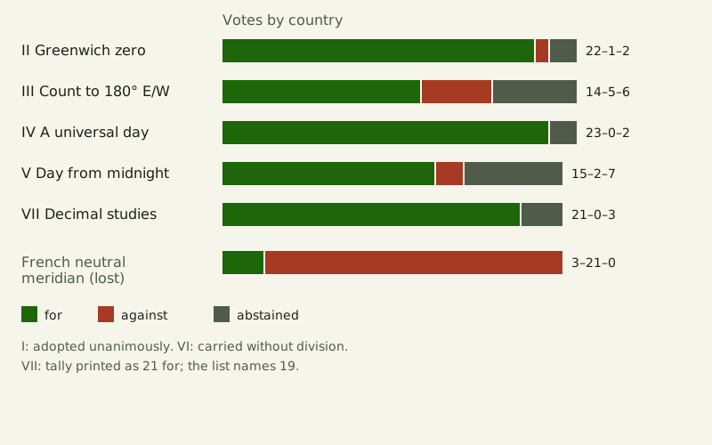
Figure: The Yardstick Almanac, CC BY 4.0
Credit line to copy
"Votes at the 1884 International Meridian Conference" by The Yardstick Almanac, https://theyardstickalmanac.com/maps/prime-meridian/, licensed under CC BY 4.0 (https://creativecommons.org/licenses/by/4.0/).
Data: International Meridian Conference, Protocols of the Proceedings (1884), public domain; 2026-11-01, CC BY 4.0
The same table in text form:
| Resolution | What it proposed | For | Against | Abstained |
|---|---|---|---|---|
| I | A single prime meridian for all nations | unanimous | 0 | 0 |
| II | The Greenwich transit instrument as the initial meridian | 22 | 1 | 2 |
| III | Longitude counted both ways to 180°, east plus, west minus | 14 | 5 | 6 |
| IV | A universal day, not replacing local or standard time | 23 | 0 | 2 |
| V | The universal day begins at mean midnight on the initial meridian | 15 | 2 | 7 |
| VI | A hope that astronomical and nautical days begin at mean midnight | carried without division | ||
| VII | Resumed studies of decimal angles and time | 21 (19 named) | 0 | 3 |
Why did the conference choose Greenwich?
The delegates had already turned down the alternative. Before Resolution II came up, the French delegates moved that the initial meridian should have “a character of absolute neutrality” and should “cut no great continent.” It lost 21 to 3, with only Brazil, France and San Domingo voting for it.
The case for Greenwich was mostly about charts. Sandford Fleming, a British delegate representing Canada, told the conference that Greenwich was “used by 72 per cent. of the whole floating commerce of the world,” with the rest split among ten other meridians. On October 6, Commander Sampson of the American delegation had argued that charts drawn on Greenwich already covered the navigable globe. Leaving their printing plates alone and changing the others, he argued, would cost the world less.
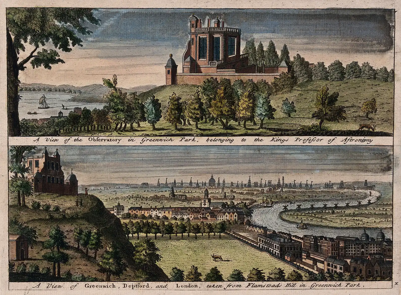
"The Royal Observatory, Greenwich Hill, top, and the view of Greenwich and London seen from the hill, below" by Wellcome Collection — https://commons.wikimedia.org/wiki/File:The_Royal_Observatory,_Greenwich_Hill,_top,_and_the_view_of_Wellcome_V0013355.jpg — CC BY 4.0 (https://creativecommons.org/licenses/by/4.0/)
Fleming himself preferred a zero on the far side of the globe. He argued that the meridian opposite Greenwich would keep every Greenwich chart usable while easing national objections, and he moved an amendment that left the choice of half open. Professor Adams, director of the Cambridge Observatory and another British delegate, rejected the idea: “The one half is just as national as the other half.”
Writing in 1900, Maunder called the outcome a matter of “pure practical convenience,” and traced it to “the amazing growth of Great Britain as a naval and commercial power.” That is his explanation, written 16 years later. The protocols show something narrower: the delegates who spoke for Greenwich argued from charts, almanacs and existing habit.
Which other prime meridians were in use?
Fleming's table, read into the protocol on October 13, counted 57,697 ships and the meridian each used to work out its longitude. Greenwich led with 37,663 ships, carrying 14,600,972 of 20,312,093 tons. Paris came second with 5,914 ships. Cadiz, Naples, Christiana, Ferro, Pulkova, Stockholm, Lisbon, Copenhagen and Rio de Janeiro followed, each with a few percent or less.
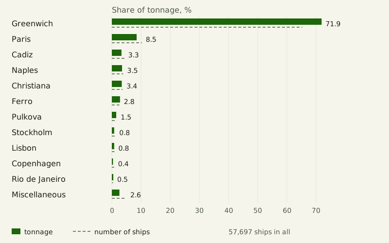
Figure: The Yardstick Almanac, CC BY 4.0
Credit line to copy
"Shipping by initial meridian, 1884" by The Yardstick Almanac, https://theyardstickalmanac.com/maps/prime-meridian/, licensed under CC BY 4.0 (https://creativecommons.org/licenses/by/4.0/).
Data: Sandford Fleming's table in the International Meridian Conference protocols (1884), public domain; recomputed 2026-11-01, CC BY 4.0
The denominator matters here. By ship count, Greenwich had 65.3 percent of Fleming's total; by tonnage, 71.9 percent, which he rounded to 72. We call that kind of switch the unstated per, the “per ship” or “per ton” that a share quietly assumes. The same problem runs through choropleth maps that color regions by raw counts.
| Initial meridian | Ships | Tonnage | Ships, % (printed) | Tonnage, % (printed) |
|---|---|---|---|---|
| Greenwich | 37,663 | 14,600,972 | 65 | 72 |
| Paris | 5,914 | 1,735,083 | 10 | 8 |
| Cadiz | 2,468 | 666,602 | 5 | 3 |
| Naples | 2,263 | 715,448 | 4 | 4 |
| Christiana | 2,128 | 695,988 | 4 | 3 |
| Ferro | 1,497 | 567,682 | 2 | 3 |
| Pulkova | 987 | 298,641 | 1.5 | 1.5 |
| Stockholm | 717 | 154,180 | 1.5 | 1 |
| Lisbon | 491 | 164,000 | 1 | 1 |
| Copenhagen | 435 | 81,888 | 1 | 0.5 |
| Rio de Janeiro | 253 | 97,040 | 0.5 | 0.5 |
| Miscellaneous | 2,881 | 534,569 | 4.5 | 2.5 |
Letters sent to the conference pushed other candidates. The president reported one proposing Jerusalem, and a committee listed a letter advocating a meridian through the Great Pyramid. Neither came to a vote.
Did the conference also set the world's clock?
In part. Resolution IV proposed “a universal day for all purposes for which it may be found convenient,” one that “shall not interfere with the use of local or other standard time where desirable.” It passed 23 to 0, with Germany and San Domingo abstaining. Resolution V then defined that day: a mean solar day, beginning “at the moment of mean midnight of the initial meridian” and counted from 0 to 24 hours; it split the room, 15 to 2 with 7 abstentions.
The argument was over noon versus midnight. Introducing Resolution V, Rutherfurd said it followed the 1883 geodetic conference at Rome with one change. Rome had tied the universal day to the astronomical day, which began at Greenwich noon.
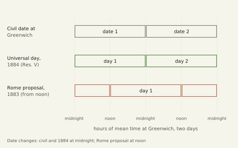
Figure: The Yardstick Almanac, CC BY 4.0
Credit line to copy
"One day at Greenwich, counted three ways" by The Yardstick Almanac, https://theyardstickalmanac.com/maps/prime-meridian/, licensed under CC BY 4.0 (https://creativecommons.org/licenses/by/4.0/).
Data: International Meridian Conference, Protocols of the Proceedings (1884), public domain; 2026-11-01, CC BY 4.0
The Russian delegates argued for midnight. With a noon start, they said, local and universal dates would differ during “the principal business hours of the day.” Astronomers, they added, could shift their reckoning by 12 hours more easily than the public could.
General Strachey of the British delegation spelled out the cost of the noon rule. Under it, he said, “the morning hours of the civil day would have a different universal date from the afternoon hours,” all over Europe. Starting at midnight and counting longitude 180° each way, he said, left a break in dates only for travelers crossing the 180th meridian. Resolution VI added a hope, carried without a division, that astronomical and nautical days would also begin at mean midnight.
By 1900, Maunder wrote, the United States and Canada had defined their standard times as “exactly so many hours slow of Greenwich mean time.” Most of Europe had followed, he added. France, which abstained in 1884, used “Paris time less 9 m. 21 s.,” the longitude difference between the two national observatories, instead of naming Greenwich. Running two reckonings side by side is the same problem, on a scale of days instead of minutes, behind Old Style and New Style dates.
What is the transit instrument at Greenwich?
In 1884 it was George Airy's transit circle. Maunder says it arrived in 1851 and “took the place both of the old transit instrument and of the mural circle.” Airy's autobiography records the plan: a new transit circle with an 8-inch object glass, set up in a different room, after which “the old Transit Instrument may be removed.”
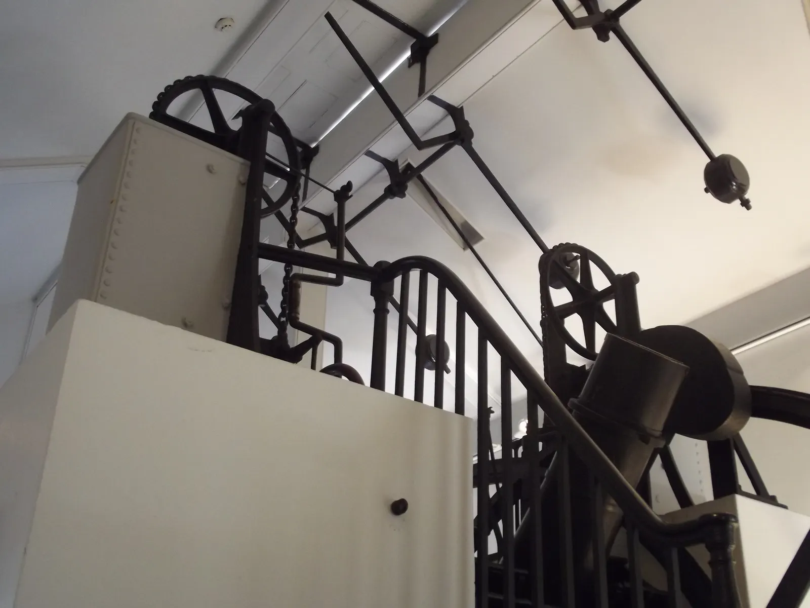
"Royal Observatory Greenwich - Airy's transit telescope" by Elliott Brown — https://commons.wikimedia.org/wiki/File:Royal_Observatory_Greenwich_-_Airy's_transit_telescope_(8128915630).jpg — CC BY 2.0 (https://creativecommons.org/licenses/by/2.0/)
Greenwich's zero had moved before 1884, by a few feet: Maunder says the transit room stands “only a few feet to the east of the first transit instrument” set up by Halley, the second Astronomer Royal. He called the gap “very much less than one-tenth of a second of time.” A tenth of a second of time is 1.5 seconds of longitude [exact by definition], about 29 m at Greenwich's latitude [estimate, range 28.6–29.2 m]. We took the range from the ground length of 1.5 seconds of longitude on the WGS 84 ellipsoid at 51° and 52° N, since Maunder puts Greenwich at “nearly 52° north.”
The telescope also moved on its own: in 1857 Airy reported a yearly swing in the instrument's azimuth, its aim relative to true north, with “the extreme range being about 14 seconds” [measured, source gives no uncertainty]. His explanation was short: “I cannot conjecture any cause for these changes, except in the motion of the ground.” Maunder describes the routine that followed. Day by day, observers measured how far the instrument was out and corrected their readings, using a basin of mercury as a level surface.
Even the clock at the gate missed. Maunder notes that “the great twenty-four-hour clock does not mark the exact meridian of Greenwich.”
Where is longitude zero today?
Today longitude zero is defined by a reference frame, not by a telescope. The International Earth Rotation and Reference Systems Service (IERS) defines the International Terrestrial Reference System with its origin at Earth's center of mass, “including oceans and atmosphere.” Its orientation was “initially given by the BIH orientation at 1984.0.” BIH is the Bureau International de l'Heure, whose 1984 frame started the series; by the chapter's 2019 update, thirteen versions of the frame had followed, from ITRF88 to ITRF2014.
The IERS Conventions say plainly that this orientation is a choice. “The orientation of the TRF, unobservable by any technique, is arbitrary or conventionally defined,” chapter 4 states. In these frames the X axis points along the prime meridian. The paper discussed below says that every realization of WGS 84 takes its orientation from the same BIH frame of 1984.
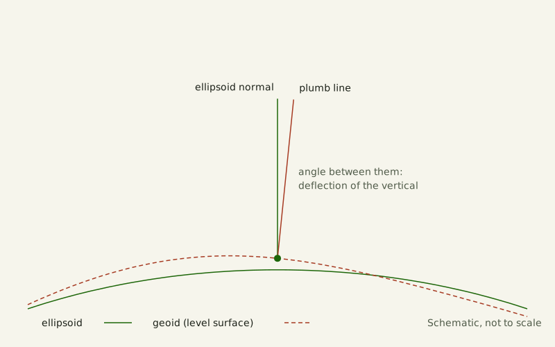
Figure: The Yardstick Almanac, CC BY 4.0
Credit line to copy
"Plumb line and ellipsoid normal" by The Yardstick Almanac, https://theyardstickalmanac.com/maps/prime-meridian/, licensed under CC BY 4.0 (https://creativecommons.org/licenses/by/4.0/).
Data: Schematic, no data values; 2026-11-01, CC BY 4.0
A 2015 Journal of Geodesy paper by Stephen Malys and four co-authors, titled “Why the Greenwich meridian moved,” says GPS does not put 0° on the Greenwich line. According to the abstract (Malys et al., 2015), visitors on the meridian line must walk east about 102 m [measured, source gives no uncertainty] before a satellite-navigation receiver reads zero longitude. The abstract attributes the offset to the deflection of the vertical in the east–west direction at Greenwich, and to keeping astronomical time continuous.
The transit circle was set up against gravity: its level was checked against a mercury surface, which lies at right angles to the local plumb line. Satellite frames use a smooth ellipsoid centered on Earth's mass instead, and where gravity tilts away from that ellipsoid's perpendicular, the two meridians part. We have read only the abstract, not the full paper, so the 102 m figure appears here as the abstract states it. The abstract adds that the orientation of the meridian plane used to measure Universal Time “has remained essentially unchanged.”
Someone at the conference saw this coming. As the protocol records the remarks of Professor Newcomb of the United States Nautical Almanac, a country that fixed its longitude by law would in effect choose a zero “whether we happened to strike the transit instrument at Greenwich or not.” Datums and frames still behave that way, which is why the same coordinates in WGS 84 and an older datum can land meters apart.
How big is a second of longitude?
On the WGS 84 ellipsoid, one second of longitude spans 30.92 m at the equator (rounded) [exact by definition] and shrinks roughly with the cosine of latitude, to 0 m at the poles. At Greenwich's latitude it is about 19 m: 19.50 m at 51° N and 19.08 m at 52° N (both rounded) [exact by definition]. Longitude can also be written in units of time, 15 seconds of arc to one second [exact by definition]. One second of time then spans 464 m at the equator and 292 to 286 m between 51° and 52° N.
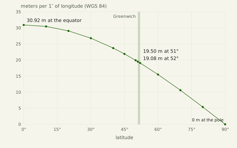
Figure: The Yardstick Almanac, CC BY 4.0
Credit line to copy
"Ground length of one second of longitude" by The Yardstick Almanac, https://theyardstickalmanac.com/maps/prime-meridian/, licensed under CC BY 4.0 (https://creativecommons.org/licenses/by/4.0/).
Data: WGS 84 ellipsoid parameters (PROJ 9.6.0, MIT); computed 2026-11-01, CC BY 4.0
| Latitude | 1″ of longitude | 1 s of time | 1′ of latitude |
|---|---|---|---|
| 0° | 30.92 m | 463.8 m | 1,842.9 m |
| 30° | 26.80 m | 402.0 m | 1,847.5 m |
| 51° | 19.50 m | 292.5 m | 1,854.1 m |
| 52° | 19.08 m | 286.2 m | 1,854.5 m |
| 60° | 15.50 m | 232.5 m | 1,856.9 m |
| 90° | 0.00 m | 0.0 m | 1,861.6 m |
We computed each value two ways: once from the ellipsoid formulas directly, and once as a geodesic distance with the pyproj library. The two agree to well under a millimeter. Latitude does not shrink like this. On the same ellipsoid, one minute of latitude stays between 1,843 m at the equator and 1,862 m at the poles (both rounded) [exact by definition], the stretch that the nautical mile is compared against.
Which countries does the prime meridian cross?
Going south from the North Pole, the 0° line crosses the United Kingdom, France, Spain, Algeria, Mali, Burkina Faso, Togo and Ghana, then open ocean until Antarctica. We traced it through Natural Earth's 1:10 million country outlines, version 5.1.2, so the list names countries and is not a survey of crossing points.
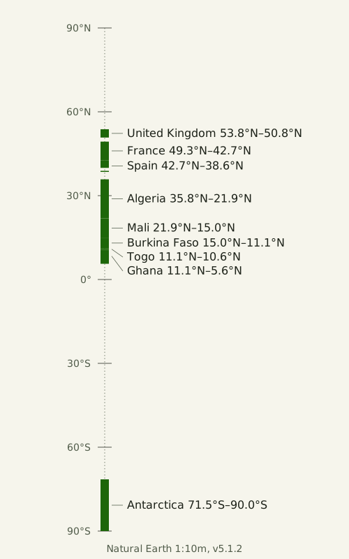
Figure: The Yardstick Almanac, CC BY 4.0
Credit line to copy
"Where the 0° meridian crosses land" by The Yardstick Almanac, https://theyardstickalmanac.com/maps/prime-meridian/, licensed under CC BY 4.0 (https://creativecommons.org/licenses/by/4.0/).
Data: Natural Earth 1:10m Admin 0 Countries, version 5.1.2, public domain; computed 2026-11-01, CC BY 4.0
In that dataset the line leaves the United Kingdom's land between 53.64° and 53.54° N. It also leaves Spain's coast near 39.9° N, crosses a stretch of sea, and runs over land again from 38.9° to 38.6° N, so both countries show two stretches. Near 11° N it runs close to the border between Togo and Ghana and passes in and out of Togo twice.
| Country or continent | Northern edge | Southern edge |
|---|---|---|
| United Kingdom (two stretches) | 53.76° N | 50.79° N |
| France | 49.33° N | 42.69° N |
| Spain (two stretches) | 42.69° N | 38.62° N |
| Algeria | 35.84° N | 21.85° N |
| Mali | 21.85° N | 14.98° N |
| Burkina Faso | 14.98° N | 11.10° N |
| Togo (two stretches) | 11.10° N | 10.59° N |
| Ghana (two stretches) | 11.09° N | 5.62° N |
| Antarctica | 71.50° S | 90.00° S |
Sources
- International Conference Held at Washington for the Purpose of Fixing a Prime Meridian and a Universal Day, October 1884: Protocols of the Proceedings (Washington, D.C.: Gibson Bros., 1884). Project Gutenberg eBook #17759. https://www.gutenberg.org/ebooks/17759 Read: full text
- E. Walter Maunder, The Royal Observatory, Greenwich: A Glance at Its History and Work (London: Religious Tract Society, 1900). Project Gutenberg eBook #44167. https://www.gutenberg.org/ebooks/44167 Read: chapters on the transit room, the transit circle and time
- George Biddell Airy, Autobiography of Sir George Biddell Airy, ed. Wilfrid Airy (Cambridge: Cambridge University Press, 1896). Project Gutenberg eBook #10655. https://www.gutenberg.org/ebooks/10655 Read: entries for 1847–1857
- IERS Conventions (2010), IERS Technical Note No. 36, chapter 4, “Terrestrial reference systems and frames” (complete chapter update as of 1 April 2019). https://iers-conventions.obspm.fr/content/chapter4/icc4.pdf Read: sections 4.1–4.2
- International Earth Rotation and Reference Systems Service (IERS), “International Terrestrial Reference System (ITRS).” https://www.iers.org/iers/en/dataproducts/itrs/itrs Read: full page
- Stephen Malys, John H. Seago, Nikolaos K. Pavlis, P. Kenneth Seidelmann and George H. Kaplan, “Why the Greenwich meridian moved,” Journal of Geodesy 89 (2015): 1263–1272. doi:10.1007/s00190-015-0844-y. https://doi.org/10.1007/s00190-015-0844-y Read: abstract only
- PROJ contributors, PROJ 9.6.0, src/ellps.cpp (ellipsoid table: WGS84, a = 6378137.0, rf = 298.257223563). MIT license. https://github.com/OSGeo/PROJ/blob/9.6.0/src/ellps.cpp Read: full file
- Natural Earth, 1:10m Cultural Vectors, Admin 0 – Countries, version 5.1.2. Public domain. https://github.com/nvkelso/natural-earth-vector/tree/v5.1.2 Read: full dataset (country polygons)
Data files (counted from the 1884 protocols, cross-checked against the printed tallies; ground lengths computed on the WGS 84 ellipsoid two ways, with pyproj 3.8.0, MIT license; country crossings computed two ways from Natural Earth version 5.1.2, public domain; each file comes with a notes file giving its sources and license):
- Votes by country, 1884 conference (CSV, source and license notes) Data: International Meridian Conference, Protocols of the Proceedings (1884), public domain; transcribed and checked 2026-11-01, CC BY 4.0
- Ships and tonnage by initial meridian, 1884 (CSV, source and license notes) Data: Sandford Fleming's table in the International Meridian Conference protocols (1884), public domain; percentages recomputed 2026-11-01, CC BY 4.0
- Length of a second of longitude by latitude (CSV, source and license notes) Data: WGS 84 ellipsoid parameters (PROJ 9.6.0, MIT); computed 2026-11-01, CC BY 4.0
- Countries crossed by the 0° meridian (CSV, source and license notes) Data: Natural Earth 1:10m Admin 0 Countries, version 5.1.2, public domain; computed 2026-11-01, CC BY 4.0
Cite this page
The Yardstick Almanac. "Prime Meridian: The 1884 Vote Named a Telescope, Not a Mark." Published November 1, 2026. https://theyardstickalmanac.com/maps/prime-meridian/. Accessed [the date you read it].
More in Maps Explained
Maps Explained
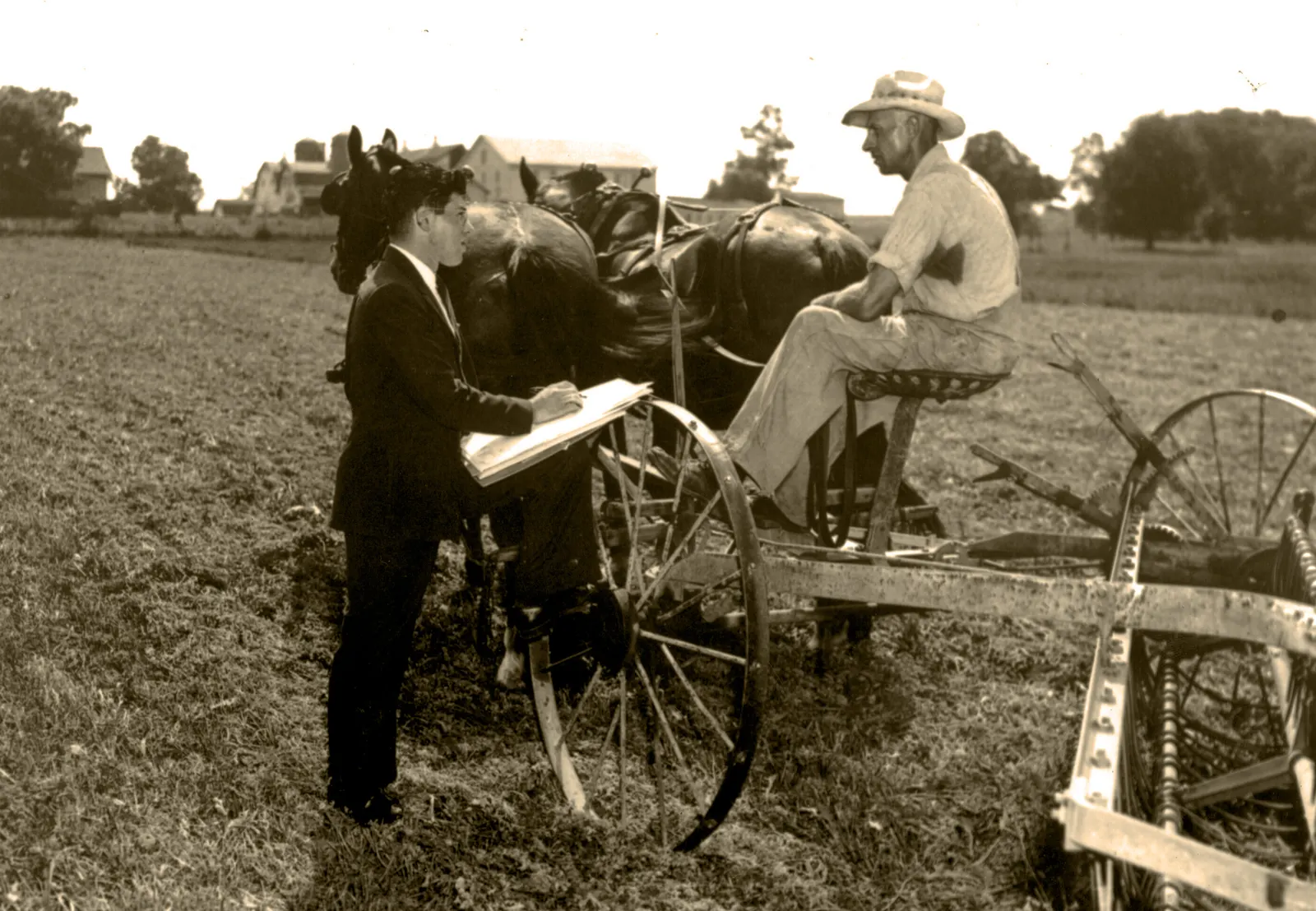
Choropleth Map: Raw Counts Mostly Redraw the Population Map
Image credit
"1940 Census Enumeration" by U.S. Census Bureau — https://commons.wikimedia.org/wiki/File:1940_Census_Enumeration_(5020520332).jpg — Public domain (work of the U.S. federal government, 17 U.S.C. §105: the Commons file page tags it as the work of a United States Census Bureau employee made as part of official duties; also released by the U.S. Census Bureau on Flickr under CC BY 2.0, which is the basis used outside the United States)
Maps Explained
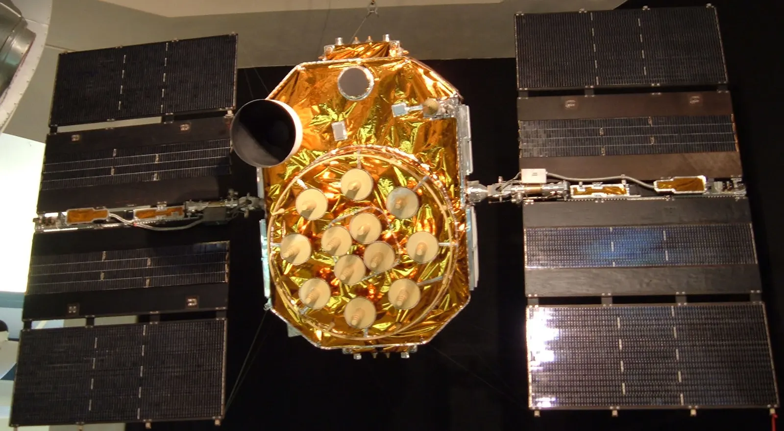
WGS 84: The Same Coordinates Can Land Meters Apart
Image credit
"Global Positioning System satellite" by Scott Ehardt — https://commons.wikimedia.org/wiki/File:Global_Positioning_System_satellite.jpg — Public domain (Author dedication, not term expiry: the photographer, Scott Ehardt, released this own work (uploaded 2 June 2005) into the public domain worldwide on the Commons file page, so it holds in the United States and in the EU alike; where a dedication is not legally possible, his fallback grant lets anyone use the work for any purpose without conditions. The photographed object is an unlaunched GPS Block II-A satellite, a utilitarian spacecraft on museum display, not a separate artwork.)
How this page is checked: Where the numbers come from explains the value tags, the source order and how every figure is recomputed.
Corrections: every substantive change is logged in What we got wrong.
Spotted an error? Email contact@theyardstickalmanac.com with the sentence and your source, or read Write in first.